Live
- Australia prepares for catastrophic bushfire over Christmas period
- Global prevalence of atopic dermatitis to reach 42.42 mn by 2033: Report
- OpenAI's GPT 5 Faces Delays Amid Data and Financial Challenges
- Sunny Leone's Name Used in Fraud Under Chhattisgarh’s Mahtari Vandan Yojana
- Gold Business Fraud Uncovered in Atmakur, Wanaparthy
- Rachakonda Police Seize Rs.88 Crore Worth Drugs, Arrest 521 Accused
- Sriram Krishnan Appointed Senior Policy Advisor for AI at the White House
- Cyclone alert at seven ports in Tamil Nadu; rain, strong winds expected
- Uttarakhand CM to attend MP govt's 'Jan Kalyan Parv' in Sagar today
- Sri Jagdamba Pearls Expands Presence with the launch of its Second Store in Bengaluru at Lulu Mall
Just In
Wow, 40-km long metro train to chug from RGIA into Fourth City


Hyderabad Airport Metro Phase II to span 116.2 km is expected to cost about `32,237 cr
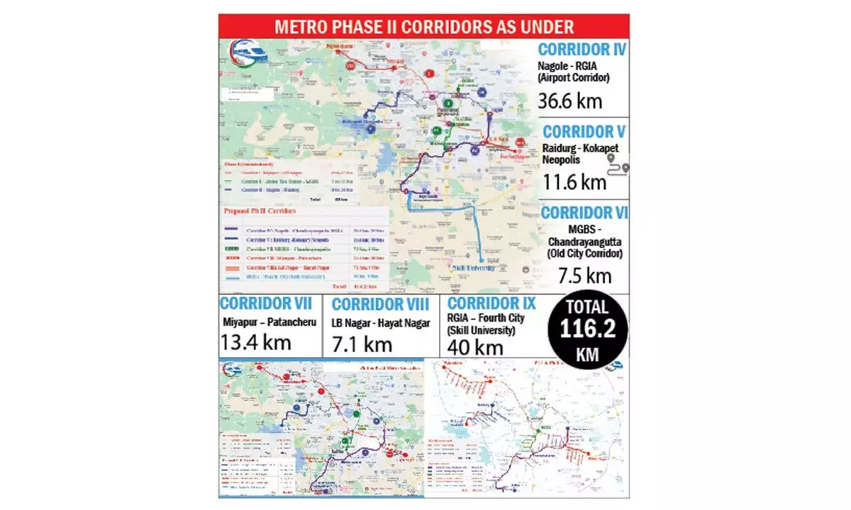
Hyderabad: Airport Metro Limited (HAML) has proposed to extend the metro rail from the international airport at Shamshabad to the proposed Fourth City via Mansanpally Road. The Outer Ring Road (ORR) stretch between the Pedda Golconda exit and the Raviryal exit is expected to cost Rs 8,000 crore. This line will be 40 km long from Shamshabad Airport to the Skill University location in the proposed Fourth City.
The entire Metro Phase II project spans 116.2 km and is expected to cost about Rs 32,237 crore, with five additional corridors estimated to cost Rs 24,237 crore. The Airport Metro corridor will run from Nagole to Shamshabad Airport via L.B Nagar, Karmanghat, Owaisi Hospital, DRDO, Chandrayangutta, Mailardevpally, Aramghar, New High Court, and Shamshabad Junction on the National Highway. This corridor will connect to all existing metro lines at Nagole, L.B Nagar, and Chandrayangutta. Of the total length of 36.6 km, 35 km will be elevated, and 1.6 km will be underground, with 24 metro stations, including one underground station at the airport.
The project is proposed to be implemented as a joint venture between the Telangana Government and the Central Government, similar to most other metro rail projects in Indian cities, with DPRs likely to be submitted in a few months. In a recent meeting chaired by Chief Minister Revanth Reddy along with senior officers, the alignments for Metro Phase II were finalized. There are also plans for better first and last-mile connectivity, including an extension of the metro up to the ORR.
NVS Reddy, Managing Director of HAML, stated that the proposed metro connection to the Fourth City will include about 2 km of underground construction within the airport area, approximately 20 km elevated, and 18 km at road level. The 18 km road level portion from the ORR Raviryal exit to the Skill University will be part of a new proposed greenfield 300 ft road. The airport metro alignment is being finalized via Aramghar and the new High Court location on National Highway 44 (Bengaluru Highway) to reach Shamshabad Airport.
Currently, HAML is awaiting the traffic study report of the Comprehensive Mobility Plan (CMP) being prepared for the Hyderabad Metropolitan Area (HMDA) to finalize the DPRs. Traffic projections for the new metro corridors must be cross-checked with the CMP as a mandatory requirement for the submission of DPRs to obtain necessary approvals from the Central Government.
Regarding the Old City metro project, which is part of Phase II, the MD stated that notifications have already been issued to 400 of the 1,100 affected properties due to road widening and the Old City metro alignment. The rest are in progress. There are about 103 religious, heritage, and other sensitive structures along this route, all of which are being preserved through appropriate engineering solutions and adjustments to metro pillar locations. There is a plan to obtain approval from the state government in October, after which it will be sent for central approval. Upon receiving approval, groundwork will commence.
Details of Metro
corridors Phase –II
The entire Metro Phase II project spans 116.2 km, and final touches are being added to the Detailed Project Report (DPR). According to metro rail officials, Corridor IV (Airport Metro Corridor) will cover a length of about 36.6 km from Nagole to Shamshabad Airport via L.B Nagar, Karmanghat, Owaisi Hospital, DRDO, Chandrayangutta, Mailardevpally, Aramghar, New High Court, and Shamshabad Junction on NH. This Airport line will connect to all existing metro lines at Nagole, L.B Nagar, and Chandrayangutta. Out of the total length of 36.6 km, 35 km will be elevated, and 1.6 km will be underground, with 24 metro stations, including one underground station at the airport.
Corridor V is being built as an extension of the Blue Line from Raidurg Metro Station to Kokapet Neopolis via Biodiversity Junction, Khajaguda Road, Nanakramguda Junction, Wipro Circle, Financial District, and Kokapet Neopolis. This corridor will be wholly elevated with about 8 stations. Corridor VI (Old City Metro) will be constructed as an extension of the Green Line from MGBS to Chandrayangutta. This 7.5 km line will travel via Mandi Road in Old City over Darulshifa Junction, Shalibanda Junction, and Falaknuma, consisting of a wholly elevated corridor with about six stations. Corridor VII will be built as an extension of the Red Line on the Mumbai Highway. Starting from the existing Miyapur metro station, this 13.4 km line to Patancheru will travel via Alwyn X Road, Madinaguda, Chanda Nagar, BHEL, and ICRISAT, featuring a wholly elevated corridor with about 10 stations. Corridor VIII will be an extension of the Red Line from the L.B Nagar side on the Vijayawada Highway. This 7.1 km corridor from L.B Nagar to Hayat Nagar will pass over Chintalkunta, Vanasthalipuram, Auto Nagar, and RTC Colony, with about 6 stations.

© 2024 Hyderabad Media House Limited/The Hans India. All rights reserved. Powered by hocalwire.com


