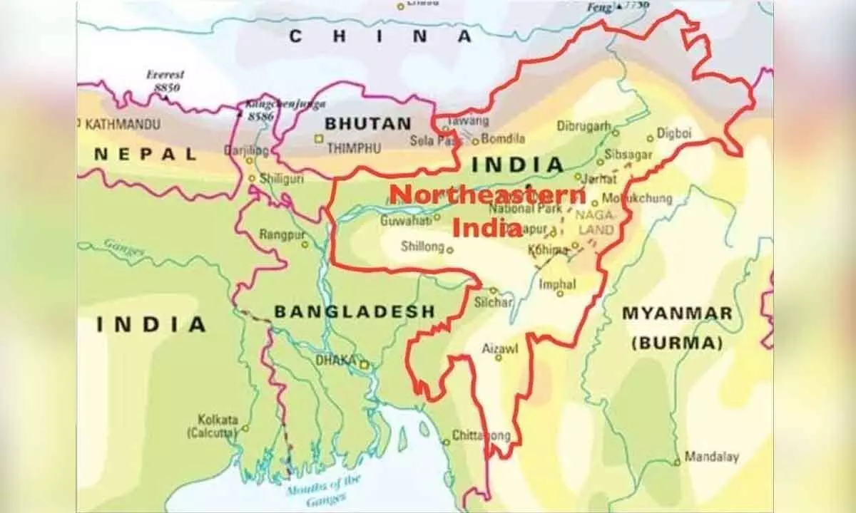
North East strife... rooted in history

The British also drew an Outer Line. No one understands the purpose of the same. Why was the Outer Line drawn and without any regulation or clear definition of its demarcation, it has been never understood by the historians at all.
The only factor that emerges to justify the Outer Line is the British interest again. The British did not seek a clear Outer Line as they sought the Inner Line with a view to avoiding any clash with the Chinese. An international border with the Chinese was not to the liking of the British. They could never occupy Arunachal Pradesh fully. The territory was too much for them to handle and they also could not match the skills of the local tribal groups which constantly fought them if they tried to intervene in their affairs.
The results: A complex and loose administration method that kept the British away from the troubles but with only power over the region. Tribal settlements here were far and few then. There were so many connectivity issues as far as transportation was concerned. The chieftains of various tribes had perfect and impenetrable defence mechanisms in place which the Britishers never understood.
Lack of interaction with the chieftains or knowledge of their warfare methods forced the Britishers on the backfoot. it was alright with them because the region did not mean much as far as revenue was concerned for the colonial rule. The British thus sought a de facto control over the region and its economy while preserving its trade routes to Tibet and Central Asia.
It would suffice to know that the Inner Line was the boundary of the local administration of districts. Outer Line meant non-answerability for the British which always allowed all privileges and rights. Lord Hardinge summed up the deliberate confusion over the Outer Line in 1910 as: “We only now claim suzerainty upto the foot of the hills. We have an Inner Line and an Outer Line. Upto the Inner Line we administer in the ordinary way. Between the Inner Line and Outer Line we only administer politically. That is, our political officers exercise very loose jurisdiction, and to prevent troubles with the frontier tribes, passes are required for our subjects who want to cross the Inner Line. The country between the two lines is very sparsely inhabited and is mostly dense jungle.”
In the absence of any well-defined international border, this line served as the exterior extent of the British Indian empire. However, this Outer Line was flexible and could be redrawn by the Empire anytime. With the Outer Line expanding, there was a provision to expand the Inner Line too. It must be made very clear here that the Inner Line was the jurisdictional and not the territorial limit of the British. Their officers cleverly defined the jurisdictional aspect: “The Chief Commissionership of Assam extends upto the borders of China and Tibet and Burma”.
They used it to pursue criminals, tribals, traders and others of any clan suitably and conveniently. When it came to the Chinese, the British did not prefer any confrontation. But both the lines effectively kept the tribal populations on a tight leash and did not facilitate their interactions with the outsiders that could lead to any exchange of ideas.
In the absence of a proper jurisdiction and the cold shouldering of the region, problems only continued to fester. While the Ahom Kingdom never had any maps to define their control over the areas, the British had the geographical knowledge but their interest being only in the protection of their tea estates etc, that is all they bothered about when it came to Arunachal-Assam borders.
The British who inherited the North East were confronted with this ‘lack of borders’ issue very much. North East meant a lot of investment on tea, coal, oil, rubber and wood and ivory and also through the opium trade. With growing business came the movement of Europeans in the region and they were not welcome by the tribals. This led to fights and killings of the Europeans in the forests.
The British then called for an Inner Line regulation meeting through the Simla Conference in 1913. It was a tripartite Conference, under the chairmanship of Sir Arthur Henry McMahon, Foreign Secretary, Government of India. McMahon played a vital role in nurturing the North East Frontier Policy.
China was represented by Ivan Chen and Lonchen Shatra, and a leading minister of the Dalai Lama represented Tibet while the head of Sikkim police, Charles Bell, who had a deep understanding of his area also sat in the meeting. The British concern was confined to an agreement with Tibet while the Chinese sought control over the entire Tibet. As discussions got prolonged over six months, finally an agreement was reached over “Outer Tibet” and “Inner Tibet”. Outer Tibet was declared as autonomous and the Chinese agreed to abstain from any interference in its administration. A fresh treaty to govern commercial relations between India and Outer Tibet was agreed upon.
Thus Tibet became a buffer between India and China. It was only in 1924 that a summary of the Simla Conference and the Boundary Agreement was published.
The overall concern of the British government was to secure the frontier with China and to keep the tribal area of Arunachal as a buffer. Syed Ali Imran, the only Indian member of the Viceroys’ Council was not very happy with this policy and pointed out that it made Arunachal Tribal areas a buffer between India and China.


